iFlightPlanner


...

Blog

Thursday, December 26, 2024

FAA Airport, Navigation & Chart Data is Current for December 26 Cycle

Thursday, December 26, 2024 @ 8:00 AM

Official airport, navigation and chart data for the FAA's 56-day AIRAC cycle beginning December 26, 2024 became current today as of 09:01Z.  This includes updated georeferenced data for airport diagrams and instrument approach procedures available in iFlightPlanner for iPad and iFlightPlanner for iPhone.

Anytime you access iFlightPlanner or iFlightPlanner for AOPA from your desktop, laptop, or smartphone browser you can be confident you're seeing the most current and accurate data available.

To ensure iFlightPlanner is current on your iPhone or iPad, simply tap "Check for Updates" in the upper-left corner of the Downloads tab.  Each app will quickly tell you which packages need to be updated!

The iFlightPlanner Crew
PLAN. FLY. LOG.

Monday, December 23, 2024

FAA Airport, Navigation & Chart Data is Available for December 26 Cycle

Monday, December 23, 2024 @ 8:00 AM

iFlightPlanner for iPad and iFlightPlanner for iPhone users may now download airport and navigation data as well as aeronautical charts, georeferenced airport diagrams and terminal procedures for the FAA Data Cycle that goes into effect on December 26, 2024.  Simply tap the button in the upper-left corner of the Downloads tab to "Check For Updates."

Pilots using iFlightPlanner for AOPA or iFlightPlanner on their desktop, laptop, or mobile device will see iFlightPlanner automatically make the transition to the new data at 9:01Z on December 26.

Friday, December 20, 2024

FLIGHT ADVISORY: Counting & Certification of Electoral Votes

Friday, December 20, 2024 @ 8:00 AM

The Federal Aviation Administration (FAA) has announced TFRs in the Washington, D.C. area on January 6, 2025, for the Counting and Certification of Electoral Votes. These airspace security measures, requested by the Department of Homeland Security, will impact the Washington, D.C. Special Flight Rules Area (DC SFRA) and the Washington, D.C. Flight Restricted Zone (DC FRZ).


iFlightPlanner.com/AviationCharts

Key Restrictions:

  • DC SFRA: No transit flights (VFR/IFR) or loitering will be permitted. VFR pattern operations at DC SFRA airports will be suspended.
  • DC FRZ: Only Department of Defense (DOD), law enforcement, and approved emergency medical flights will be allowed. Strict coordination is required for arrivals and departures from Joint Base Andrews (KADW) and Davison Army Airfield (KDAA).
  • Suspended Activities: Flight training, practice approaches, aerobatic flights, glider and parachute operations, drone usage, and banner towing are strictly prohibited.
  • Waivers & Exceptions: All flight waivers for the FRZ/P56 are suspended unless they begin with ELO, GOV, SPO, DAS, DOD, LEO, or LFG and have prior ASOC approval.

The FAA will release full NOTAM details by January 1, 2025. Pilots operating in the National Capital Region should stay updated and contact Flight Service (1-800-WX-BRIEF) before flying.

For official inquiries, the National Capital Region Coordination Center (NCRCC) can be reached at (703) 563-3221. Stay informed and plan accordingly to ensure compliance with these enhanced security measures.

Monday, December 16, 2024

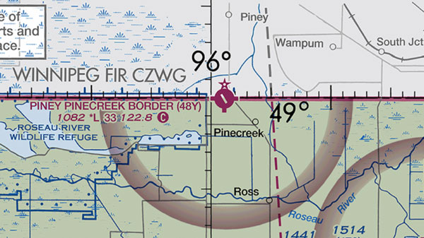
Piney-Pinecreek Border Airport (48Y) at Canadian Border Closing

Monday, December 16, 2024 @ 8:00 AM

The Piney-Pinecreek Border Airport (48Y), a general aviation airport located near Roseau, Minnesota, will permanently close on December 27, 2024.

iFlightPlanner.com/AviationCharts

Operated under an international agreement between the Minnesota Department of Transportation (MnDOT) and Piney, Manitoba, the airport saw minimal use and faced high maintenance costs, including necessary runway, apron, and terminal upgrades. With the agreement expiring on December 26, neither party has chosen to renew it.

Several nearby airports, including Warroad Memorial International (KRRT), Roseau Municipal (KROX), Stephen Municipal (D41), and Warren Municipal (D37), offer alternative options for the region’s general aviation needs. State officials note that these airports have more annual operations and support based aircraft.

More details can be found at dot.state.mn.us/aero.