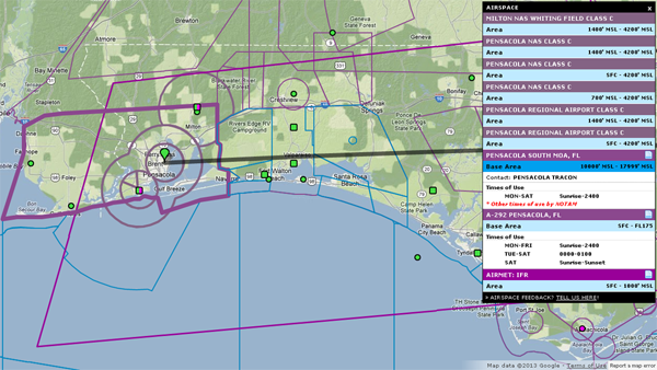
The iFlightPlanner Crew is excited to announce that all iFlightPlanner.com maps, namely the VFR and IFR charts at iFlightPlanner.com/AviationCharts and those found in the Flight Wizard, now offer complete airspace functionality. Special Use Airspace (NSA, MOA, Alert, Warning, Prohibited, & Restricted) and Class B, C, D and E airspace information all with their respective details will be available at no cost for 60-days as part of our new iFlightPlanner Premium Feature initiative.

To view airspace for any location on the map, simply left or right click with your mouse and select the "View Airspace Info" option. iFlightPlanner.com will pull the most up-to-date airspace info from our servers and display the areas visually on the map as well as in a popup that will contain as much additional airspace information as is available, including:
- Distinct airspace areas
- Vertical altitude limits
- Times of use
- Contact information
By hovering over the "Area" definition you will see the specific airspace outline highlighted on the map, a feature that helps you distinguish between different areas of complex airspace. Airspace with text definitions will have a page icon that can be clicked to view the full airspace definition. This is especially useful for TFRs, MOAs and other special use airspace which may contain very specific text instructions.
There is a new iFlightPlanner Forum thread for the SUA and Class Airspace feature and we encourage you to kick the tires and put each new feature through the ringer. Let us know what you like, what needs to be tweaked and how we can continue to make iFlightPlanner the best resource for you!
The iFlightPlanner Crew
PLAN. FLY. LOG.™

