iFlightPlanner


...

Blog

Thursday, March 29, 2018

FAA Airport, Navigation & Chart Data is Current for 03/29 Cycle

Thursday, March 29, 2018 @ 8:00 AM

Official airport, navigation and chart data for the FAA's 56-day AIRAC cycle beginning 3/29/2018 became current today as of 09:01Z.  This includes updated georeferenced data for airport diagrams and instrument approach procedures available in iFlightPlanner for iPad.

Anytime you access iFlightPlanner.com from your desktop, laptop, or smartphone you can be confident that you are seeing the most current and accurate data available.  To ensure that iFlightPlanner for iPad is current, simply tap "Check for Updates" in the upper-left corner of the Downloads tab.  The app will quickly tell you which packages need to be updated!

The iFlightPlanner Crew
PLAN. FLY. LOG.

Monday, March 26, 2018

FAA Airport, Navigation & Chart Data Available for 03/29 Cycle

Monday, March 26, 2018 @ 8:00 AM

iFlightPlanner for iPad users may now download airport and navigation data as well as aeronautical charts, georeferenced airport diagrams and terminal procedures for the FAA Data Cycle that goes into effect on March 29, 2018.  Simply tap the button in the upper-left corner of the Downloads tab to "Check For Updates".

Pilots using iFlightPlanner.com on their desktop, laptop, or smartphone will see the iFlightPlanner Cloud automatically make the transition to the new data at 9:01Z on March 29.

Friday, March 23, 2018

Flight Plan Changes in Effect for DC FRZ

Friday, March 23, 2018 @ 8:00 AM

Effective Thursday, March 29, 2018 at 0401Z, the FAA will transfer responsibility for filing flight plans in the Washington DC Flight Restricted Zone (FRZ) from Flight Service to the Flight Data Unit (FDU) located at the Washington Air Route Traffic Control Center (ZDC) per a recent Flight Advisory.

Pilots will call (703) 771-3476 to file FRZ flight plans and identify themselves using their assigned waiver number and/or confidential pilot identification number. This includes all flights in/out of the FRZ, Maryland Three Program (MD3) airports, and the general aviation operations to/from DCA (DASSP Program).

In addition, all pilots flying under Visual Flight Rules (VFR) within 60nm of the DCA VOR/DME must complete special awareness training for the Washington DC Metropolitan Area. Please visit the FAA Safety website to learn more about requirements for flying in the DC FRZ.

Monday, March 19, 2018

NTSB Warns Pilots About Weight & Balance

Monday, March 19, 2018 @ 8:00 AM

?The National Transportation Safety Board has issued a Safety Alert for General Aviation pilots, called “Minding Weight, Maintaining Balance: Improper or Unperformed Calculations Can Be Fatal.”

Between 2008 and 2016, the probable causes of 136 general aviation (GA) accidents were related to pilots improperly conducting preflight performance calculations for weight and balance or not conducting them at all. One-third of these accidents resulted in pilot and/or passenger deaths.

iFlightPlanner makes it easy to calculate your Weight & Balance based on your specific make/model aircraft, your passenger and cargo load, and planned fuel burn so there's no excuse not to!

» Calculate Weight & Balance

Monday, March 5, 2018

Major Sporting & Entertainment Events in March 1 FAA NOTAM

Monday, March 5, 2018 @ 8:00 AM

In anticipation of the large number of aircraft operating to and from areas hosting major sporting and entertainment events, the FAA has published updated procedures in its March 1, 2018 NOTAM to enhance safety and minimize air traffic delays.

THESE PROCEDURES MAY BE REVISED OR UNAVAILABLE AT THE TIME OF THE EVENT.  PILOTS SHOULD CHECK NOTAMS AND TRAFFIC ADVISORIES PRIOR TO DEPARTURE TO ENSURE THE MOST CURRENT INFORMATION. THESE NOTAMS DO NOT SUPERCEDE RESTRICTIONS PERTAINING TO THE USE OF AIRSPACE CONTAINED IN FDC NOTAMS.

Thursday, March 1, 2018

NEW! Dynamic Fuel Finder & Custom Airspace Tool

Thursday, March 1, 2018 @ 9:00 AM

We are excited to introduce an all-new Dynamic Fuel Finder and Custom Airspace Tool today, both the result of a soon-to-be-released overhaul of our web planning platform...  Click any of the screenshots below for access to our freely accessible aviation charts interface at www.iFlightPlanner.com/AviationCharts to try them out!

Dynamic Fuel Finder

Use the Dynamic Fuel Finder to identify the best fuel prices around any location, and quickly add that airport to your trip with just a few clicks!  All prices are color-coded using the same algorithm used in our Graphical Fuel Price Map Layers that were highlighted in iFlightPlanner's 4 Tools to Help Burn Less Fuel and Fly Faster tutorial.
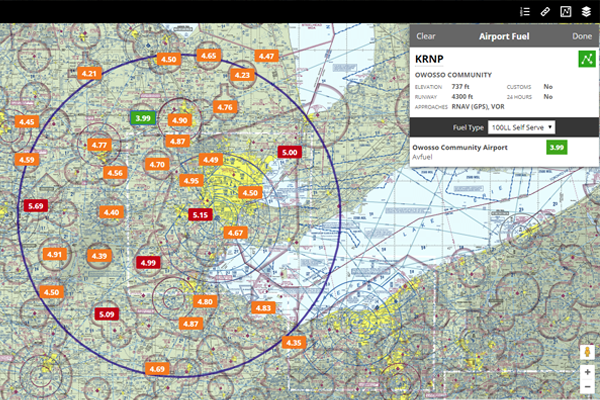
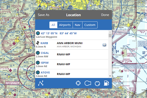
Start by clicking the fuel tank icon in the footer of the Location menu.  iFlightPlanner will search and display all airports within a 75nm radius of your chosen location, whether it's along a route you've already planned or in the vicinity of your next destination.  Clicking a fuel price will reveal that facility's Airport Fuel menu with details about the airport and the pricing offered by each FBO.  To add the airport to your route, simply click the green, "Add To Route" button and you'll be on your way!

Custom Airspace Tool

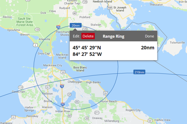
The all-new airspace tool gives you the ability to add custom range rings or circular airspace of any size, around any location, airport, or navaid, with user-defined altitude limits!  Each range ring can be set to display during all planning sessions, for a particular trip, or for a specific flight only.

This feature is perfect for UAS operators wanting to identify their center of operations just as it is for general aviation pilots in search of fun destinations within the range of their aircraft!
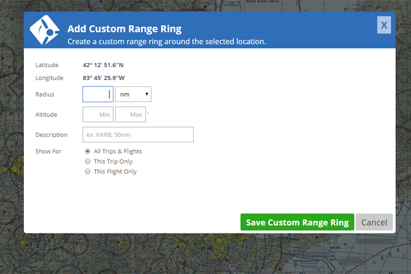
The Custom Airspace Tool is accessed by clicking the icon to the left of the fuel tank.  Simply enter the radius, altitude limits, and a name or description, and click "Save Custom Range Ring."  To edit or delete an existing range ring, click on the label as shown here.
Location Menu

The Location Menu, which is where steps to use the new Dynamic Fuel Finder and Custom Airspace Tool begin, is accessed by a single click in any of iFlightPlanner's web-based mapping interfaces.  This redesign allows us to add other location-based enhancements in the future, so stay tuned!
If you have any questions about these new features, or have an idea for a new one you would like to see added to iFlightPlanner, please contact us!

FAA Airport, Navigation & Chart Data is Current for 03/01 Cycle

Thursday, March 1, 2018 @ 8:00 AM

Official airport, navigation and chart data for the FAA's 28-day AIRAC cycle beginning 3/1/2018 became current today as of 09:01Z.  This includes updated georeferenced data for airport diagrams and instrument approach procedures available in iFlightPlanner for iPad.

Anytime you access iFlightPlanner.com from your desktop, laptop, or smartphone you can be confident that you are seeing the most current and accurate data available.  To ensure that iFlightPlanner for iPad is current, simply tap "Check for Updates" in the upper-left corner of the Downloads tab.  The app will quickly tell you which packages need to be updated!

The iFlightPlanner Crew
PLAN. FLY. LOG.